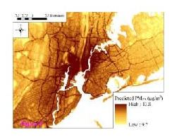
Today we review a paper describing how a statistical model can be used to provide the necessary spatial detail on the exposure to particulate matter. Knowing this is especially important near major roads in urban areas where there is a high volume of diesel powered vehicles which emit PM2.5 and where the distance from the emission sources to where people live or work is critical. The authors show examples of the mapping for cities such as New York as well as across the USA.
Key Quotes:
“epidemiologic studies of the chronic health effects of PM air pollution have used crude methods to assess particulate exposures, estimating subject’s chronic exposure either by imputing ambient concentrations from the nearest monitor or by using area-wide averages [2], thus ignoring within-city spatial gradients in air pollutant levels and restricting these studies to areas with nearby monitoring data. “
“Our models provide estimates of monthly-average outdoor concentrations of PM2.5, PM10, and PM2.5–10 with high spatial resolution and low bias. For PM2.5 and PM10, the models performed well in urban and rural areas and across seasons”


No comments:
Post a Comment